
Dolores River exceeded same-day-of-year historical maximum recorded flows in October
Dolores River exceeded same-day-of-year historical maximum recorded flows in October
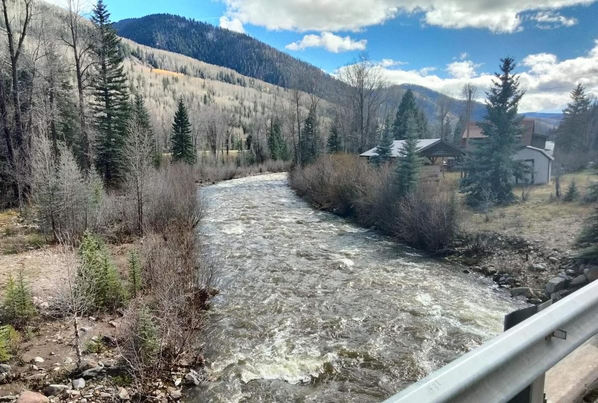
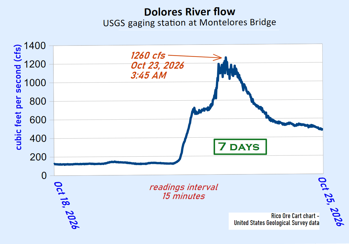
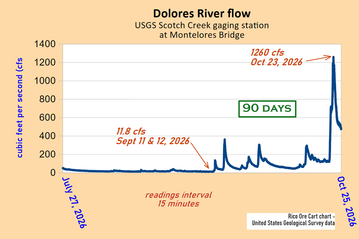
Peak flow October 23, 2026 was 107 times greater than September low.
> above
Dolores River at West Rico bridge
Ore Cart photo
October 26, 2026
by Allyn Svoboda
Publisher
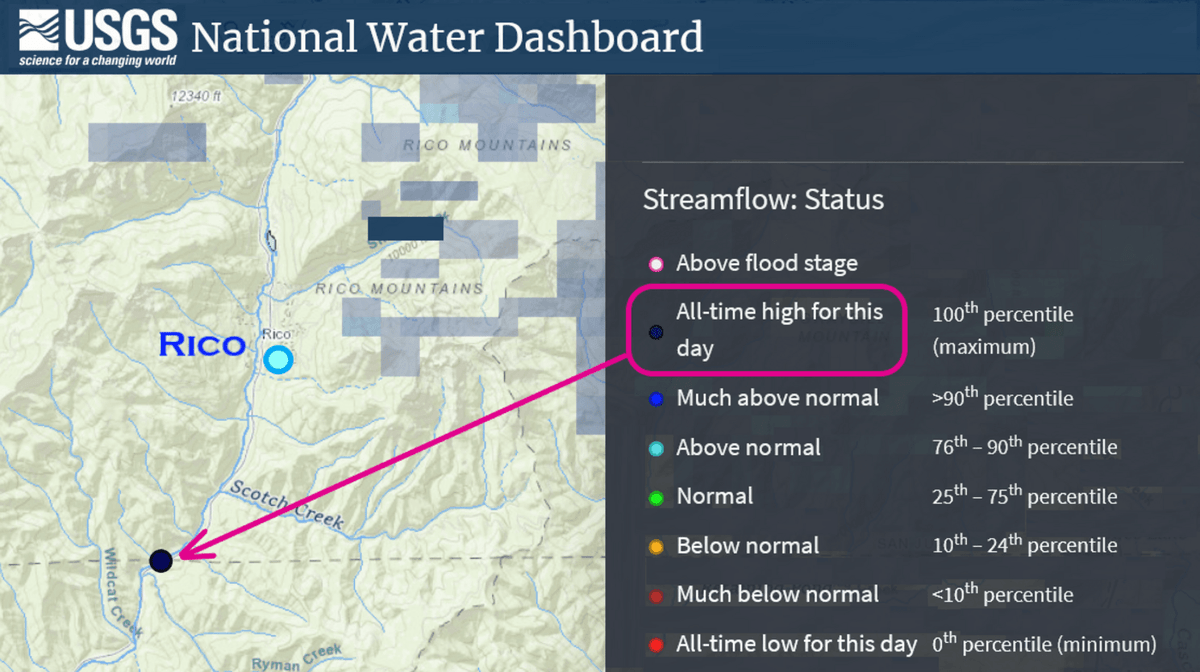
The United States Geological Survey (USGS) gaging station at the Montelores Bridge south of Rico registered several "All-time high for this day" streamflows for same-day-of-year in the last week of October 2026. USGS daily average streamflow history for this location is 73 years, according to chart notes.
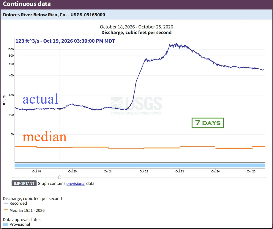
October 18 - 25, 2026 actual vs. median
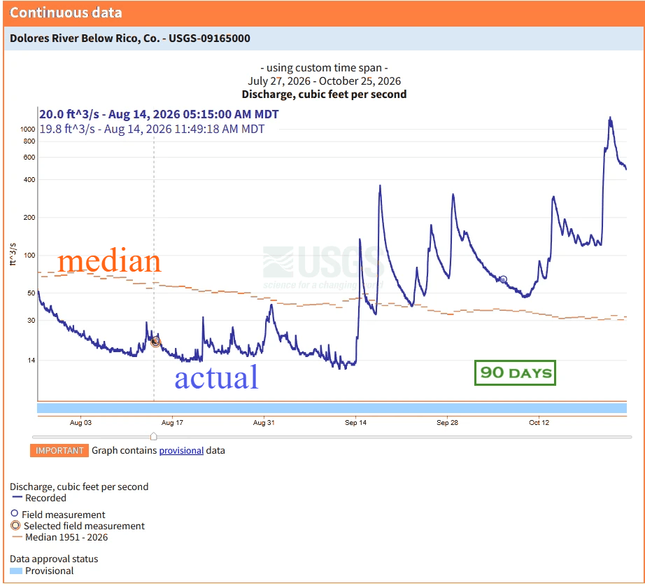
Two USGS graphs below depict Dolores River streamflows south of Rico for 7 and 90-day periods ending October 25, 2026. Vertical distance between larger numbers at the top of the left scale are compressed so that differences between smaller results at the bottom are easier to see.
Median is the middle rank of 73 years of flow readings - half of the results are above and half are below.
Streamflow readings are in 15-minutes intervals.
Chart edits by Ore Cart
added labels and color change
to "median" lines.
. . .
More than 100X swing from low to high streamflows
The next two charts show Dolores River cubic feet per second flow for the same 7 and 90-day periods ending October 25, 2026. These charts created by Ore Cart from USGS data remove vertical compression to depict the low-to-high range in a more realistic visual format.
. . .
September precipation was above normal
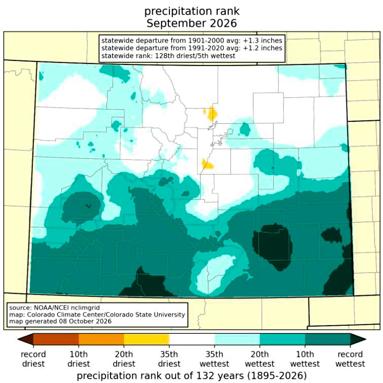
Southwest Colorado experienced a wetter than normal September, according to the Colorado Climate Center at Colorado State University. The Rico area was in the "10th wettest" month range.
A monthly report for October Colorado climate was not available on the date of this Ore Cart report.
COLORADO CLIMATE CENTER
September 2026
Colorado Monthly Climate Summary
Colorado State University
September was extremely wet in southern Colorado, with multiple surges of subtropical moisture in the second half of the month. Some spots in both southwestern and southeastern Colorado tallied their wettest September on record. In contrast, northern Colorado did not fare as well, with some Front Range locations seeing less than half of their typical September precipitation.
USGS Provisional Data Statement
This information is preliminary or provisional and is subject to revision. It is being provided to meet the need for timely best science. The information has not received final approval by the U.S. Geological Survey (USGS) and is provided on the condition that neither the USGS nor the U.S. Government shall be held liable for any damages resulting from the authorized or unauthorized use of the information.
Improbable values of current conditions data relayed by satellite or other telemetry are automatically screened until they can be verified. Provisional data may be inaccurate due to instrument malfunctions or physical changes at the measurement site. Subsequent review based on field inspections and measurements may result in substantial revisions to the data.
Data users are cautioned to consider carefully the provisional nature of the information before using it for decisions that concern personal or public safety or the conduct of business that involves substantial monetary or operational consequences. Information concerning the accuracy and appropriate uses of these data or concerning other hydrologic data may be obtained from the USGS.
SUBSCRIBE
to Rico Ore Cart
new reports announcements
- - -
enter email address below
